2020 Magna Earthquake

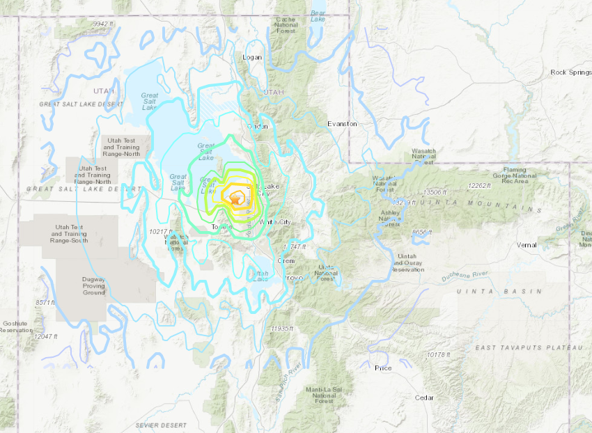
Utah experienced a magnitude (M) 5.7 earthquake on March 18, 2020 at 7:09 a.m.

Magnitude vs Time

Interactive Earthquake Intensity Map - United State Geological Survey

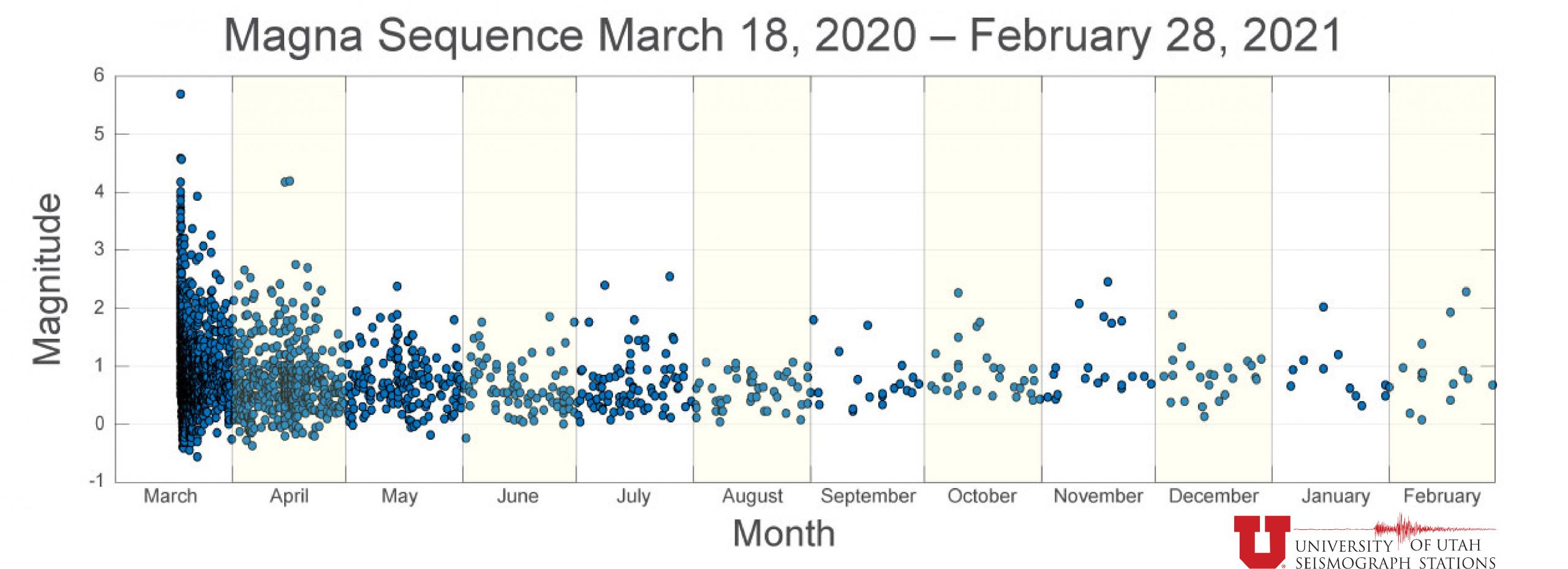
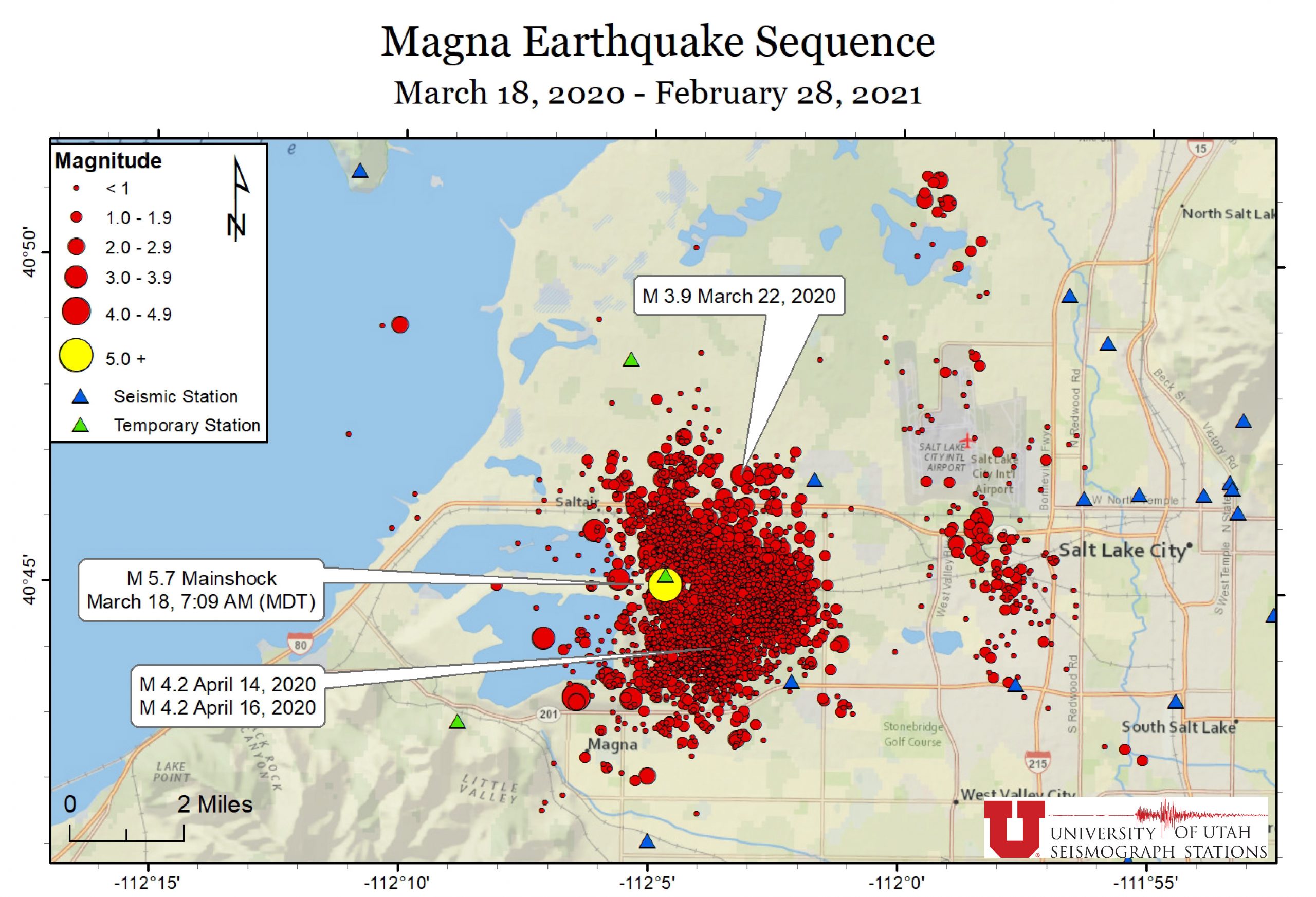
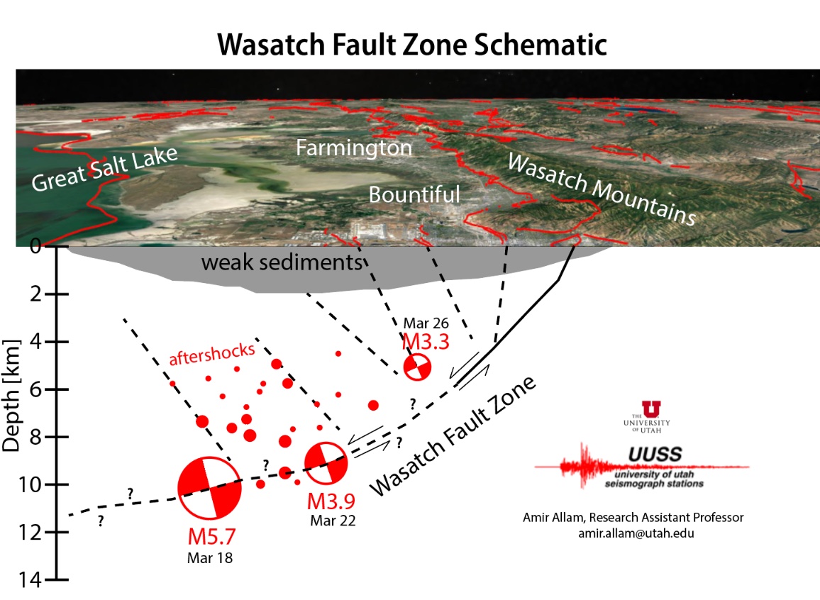
On the morning of Wednesday, March 18, 2020, northern Utah experienced a magnitude (M) 5.7 earthquake with an epicenter north of Magna, Utah. The mainshock was widely felt across the Wasatch Front with over 30,000 felt reports received by USGS and UUSS. More than 2,500 aftershocks occurred after the initial M5.7 earthquake. Utah experienced occasional spikes of felt aftershocks of M4.0 or M3.0 for weeks and months afterward.

The count includes:
1 in the magnitude 5.0 – 5.9 range
6 in the magnitude 4.0 – 4.9 range
30 in the magnitude 3.0 – 3.9 range
137 in the magnitude 2.0 – 2.9 range
698 in the magnitude 1.0 – 1.9 range
1,507 in the magnitude 0 – 0.9 range
111 less than magnitude 0 or undetermined

Aftershocks
The University of Utah Seismograph Stations (UUSS) has located 2,590 earthquakes that occurred in the Magna, Utah, area from March 18, 2020, through February 28, 2021. The largest of these earthquakes was the magnitude (M) 5.7 mainshock that occurred at 7:09 a.m. on Wednesday, March 18. The remaining 2,589 earthquakes were aftershocks. The largest aftershocks were two M4.6 events that occurred at 8:02 a.m. and 1:12 p.m. on Wednesday, March 18. Two M4.2 aftershocks occurred on April 14 and 17th which were widely felt along the Wasatch Front.

Magnitude vs Time

Recent Seismicity Map
Timeline of Magna earthquakes March 18 - April 7, 2020 (Utah Geological Survey)

Magna Quake Anniversary Town Hall
In March 2020, a 5.7M earthquake hit Magna, UT. What were the impacts? What did we learn from it? How should we prepare mentally and physically for the next one? Hear from the experts what you can do to help yourself, your family, and your community be ready for the next one.

Wade Mathews, CPM, MEP PIO/Be Ready Utah Section Manager, Division of Emergency Management

Keith D. Koper, Professor in Dept. of Geology & Geophysics, Director of Seismograph Stations, University of Utah

Clint S. Mecham, Director/Battalion Chief Salt Lake County Emergency Management/Unified Fire Authority Division

Emily Kleber, Project Geologist with the Geologic Hazards Program at the Utah Geological Survey in Salt Lake City, Utah.

John Crofts, MBA, CFM Utah Earthquake Program Manager, Utah Division of Emergency Management

Kevin Broderick, LMFT Crisis Counselor, Utah Strong Recovery Project, DHS

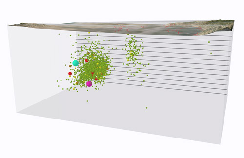
Geology of the Magna Earthquake

Image

2020 M5.7 Magna, Utah Earthquake Locations
Updated: February 28, 2021, with 2,451 events

The M5.7 earthquake and subsequent aftershocks occurred in bedrock. Valley deposits of clay, silt, sand, and gravel in the area are between 200 and 1000 feet thick. The earthquake and aftershocks occurred at depths of about 1 to 8 miles. During the earthquake, the bedrock slid past itself along a crack called a fault. Before the earthquake, friction along the fault kept the bedrock from moving. Then, when stresses in the rock finally built up to overcome the frictional resistance on the fault, the bedrock moved and the stress was released, causing the earthquake. With each break (or rupture) of a fault, the rocks around the earthquake adjust and move in the same fashion; this period of adjustment is shown by the grouping of aftershocks. Based on data from the Magna sequence, several research papers now suggest the sequence occurred on the Salt Lake City Segment of the Wasatch fault.
Interactive 3D Model of Magna Earthquake Sequence
Geologic Features
Preliminary Models and Research
Prior to the Magna earthquake, the exact location of the Wasatch fault was unknown, but many scientists thought it dipped at a steep angle deep beneath the Salt Lake Valley. Based on data from the Magna sequence, several research papers now suggest the sequence actually occurred on the Salt Lake City Segment of the Wasatch fault. Evidence also suggests that the fault curves to a gentler angle and is not as deep beneath the surface as previously thought. Multiple research papers conclude that because of the likely gentler dip of the fault, which would put it closer to the surface, ground shaking may be higher than previously estimated for future earthquakes on the Salt Lake City segment of the Wasatch fault. Additional research published to date includes increasing the number of detected earthquakes through machine learning, testing novel methods for magnitude determination, and documenting the challenges of responding to an earthquake during a pandemic. 

Example

This conceptual model illustrates one possible scenario for the location of the M5.7 Magna earthquake and its aftershocks relative to the Wasatch fault and associated faults. The M5.7 earthquake and some of its aftershocks might be on the Wasatch fault or on another nearby fault in the network of faults known as the Wasatch fault system. It is difficult to know for certain which fault or faults these earthquakes occurred on because the locations of these faults at depth are poorly known.
View More Research

Damages and Assistance

No major injuries were reported from the mainshock or aftershocks. Damages occurred throughout the valley with the most severe damage in Magna. HAZUS, software used by the state to estimate potential losses, shows that there could be upwards of $62 million in building-related damages, contributing to $629 million in total economic losses related to buildings. This does not include damages to public infrastructure.

Current Funding Assistance Totals

APPROVED INDIVIDUAL ASSISTANCE
$0
fema registrations
0

approved sba loan applicants
0

Total of SBA Loans approved
$0

Magna Quake Frequently Asked Questions

For more general earthquake FAQs, visit our homepage FAQs section.

Geology:

social: