
And why we don’t expect an earthquake of that size in Utah.
On Good Friday, March 27, 1964, at 5:36 p.m. local time, the earth began to shake in the subduction zone in the Prince William Sound in Alaska.
The U.S. Geological Survey reports that:
The earthquake caused rivers, lakes, and other waterways to slosh as far away as the coasts of Texas and Louisiana. Water-level recorders in 47 states—the entire Nation except for Connecticut, Delaware, and Rhode Island— registered the earthquake. It was so large that it caused the entire Earth to ring like a bell: vibrations that were among the first of their kind ever recorded by modern instruments.
U.S.G.S. Fact sheet, 2014
The magnitude 9.2 quake was the largest earthquake recorded in the United States and the second-largest earthquake ever recorded by modern instruments. The largest quake on record was the M9.5 event in Chile in 1960.
The U.S. Geological Survey also reports that parts of the coast sank, or subsided, as much as 8 feet, and other parts rose by as much as 38 feet.
How a subduction zone works
This Steven Eberlein TEDx talk describes how the Juan de Fuca Plate, a relatively small tectonic plate, is sliding under the North American Plate in the Pacific Northwest. Though the Alaska quake happened at a different plate boundary, this animation is excellent and demonstrates subduction zones.
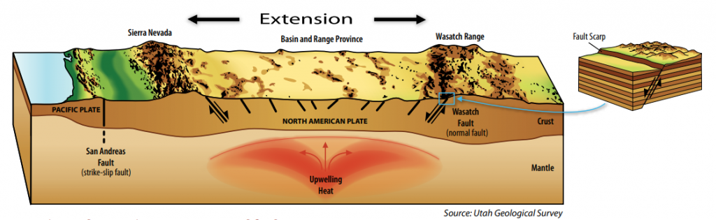
So how does this compare to Utah’s faults?
Subduction zones have the ability to generate much more energy (magnitude) through their earthquakes, than the type of fault zones we have in Utah.
Most of Utah’s faults are normal faults, which, in our case, occur in the middle of a tectonic plate. Much of Nevada and Utah is part of the Great Basin, which sits right on top of the North American Plate. The North American Plate is not sliding under another plate; it is expanding due to heat from the earth’s mantle. Anciently, what we now know as San Francisco and Salt Lake City were about 300 miles apart. Over the past 30 million years, because of this expansion, the space between San Francisco and Salt Lake City has doubled.
Why can’t we have a magnitude 9 earthquake here?
Faults in Utah are just not long enough to produce a magnitude 9 earthquake. Also, normal faults typically don’t generate the energy release that a subduction zone fault can. Subduction zones can be found off the coast of Alaska, Washington State, and the west coast of South America (Chile area), where earthquakes of magnitude 8 or greater are possible.
According to research, Utah’s worst-case scenario would be a magnitude 7.0 to magnitude 7.5.
Shaking from an earthquake of that magnitude would still be devastating. The Division of Emergency Management produced this video in 2011 to teach people about why earthquake preparedness is so important.
Joe Dougherty is the public information officer for the Utah Division of Emergency Management. [email protected]