
What changes do you make when 80 percent of the city is destroyed? How do you plan ahead so this doesn’t happen here?
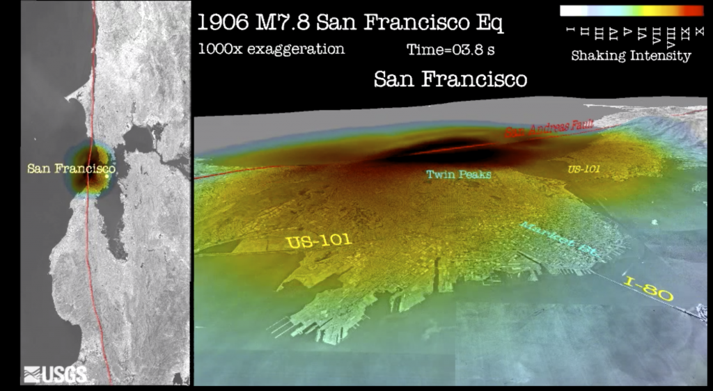
114 years ago today, at 5:12 a.m., what is understood to be a magnitude 7.9 earthquake struck the coast of northern California. Shaking lasted for 42 seconds and was felt from Oregon to Los Angeles. The earthquake, located on the San Andreas Fault, led to the following:
- About 3,000 deaths
- 225,000 rendered homeless
- 28,000 buildings destroyed
- $80 million in building damages.
Where it happened
The San Andreas Fault, one of the most well-known faults in the United States, is known as a strike-slip fault, where tectonic plate boundaries are slipping past each other. Los Angeles, which sits on the Pacific Plate, and San Francisco, on the North American Plate, are moving toward each other at the rate of about 1 to 2 inches per year. One day, they will be adjacent to each other.

The U.S. Geological Survey reports:
During the 1906 earthquake in the San Francisco region, roads, fences, and rows of trees and bushes that crossed the fault were offset several yards, and the road across the head of Tomales Bay was offset almost 21 feet, the maximum offset recorded. In each case, the ground west of the fault moved relatively northward. Source: U.S.G.S. “What kind of movement has happened along the (San Andreas) fault?
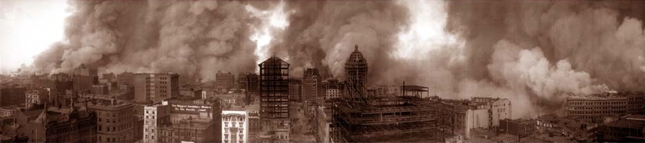
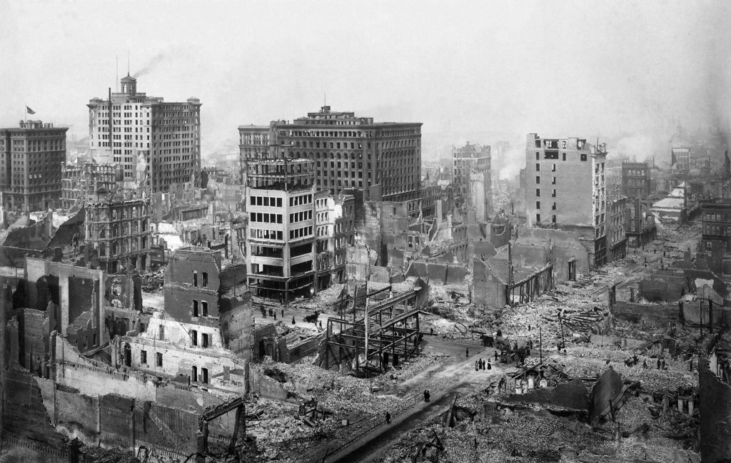
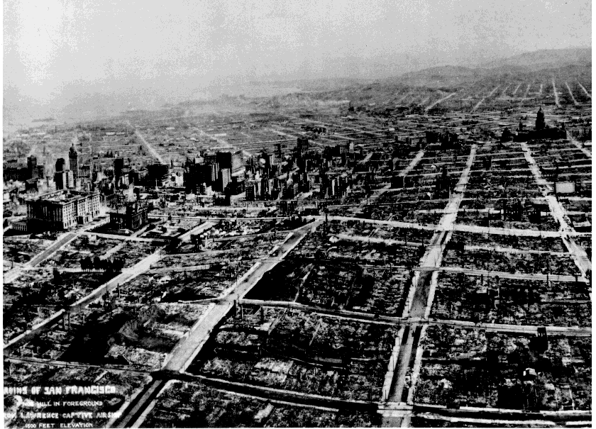
What happened after the earthquake nearly quintupled the devastation
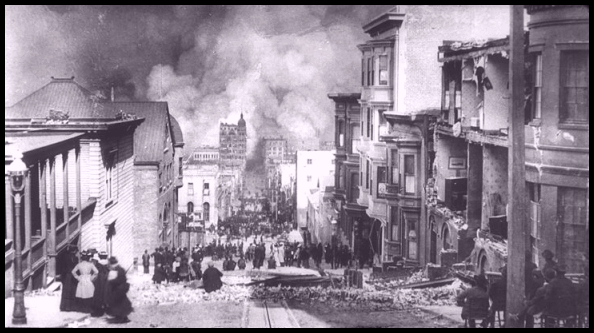
Following the earthquake, fires broke out throughout the city. Some were caused accidentally. Others erupted from broken gas mains. Some buildings caught fire after an attempt by firefighters to dynamite buildings to make fire breaks.
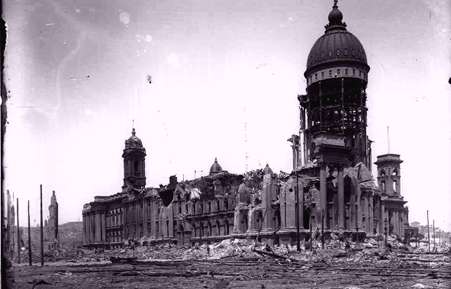
The earthquake damage is estimated to have caused $80 million in damages.
The fires, some of which were conflagrations, are believed to have raised the damage total to $400 million. See photo gallery below.
Conflagration: Extensive and destructive fire, usually uncontrolled
disaster words
How do you rebuild a city?
Recovery from a disaster like the San Francisco earthquake and its subsequent fires led to significant changes in building construction and planning in San Francisco and throughout California.
Infrastructure always needs repairs first, and within days, plumbers got to work, fixing sewers and water pipes. As California contemplated how to rebuild, the state had to take a hard look at building codes, the rules for how to keep people safe in buildings.
At the time of the 1906 San Francisco earthquake, many California municipalities had building codes, but none considered seismic effects…
Stanford University centennial commemoration of the earthquake
Professional organizations, particularly the Seismological Society of America, which formed in 1906, and later, the Structural Engineers Association of California, were persistent advocates of code provisions for earthquake-resistant construction.
Various cities across the state began updating building codes to require buildings withstand seismic forces, but it still wasn’t until the 1960s that those codes became uniform across the state.
How can we mitigate earthquake damage in Utah?
Though our Wasatch fault in Utah is next to a large population center, it is a different type of fault from San Andreas.
We need to consider personal preparedness. Prepared people are resilient people. Most Utahns, we expect 99.9 percent, will survive even our worst-case scenario earthquake, which would be a magnitude 7 to 7.5. The question is what kind of disaster recovery do you want to have?
We also need to consider building preparedness and safety. Despite lots of new construction, Utah still has 147,000 unreinforced masonry buildings, most of which are homes. These buildings and homes were built before modern seismic standards. URMs are buildings made of brick or block that have no reinforcing rebar to hold them together during severe shaking of a major earthquake. These buildings are at a significantly higher risk for damage and destruction during a large earthquake.
Salt Lake City residents who live in URMs can apply for a grant from the city that covers 75 percent of certain retrofitting costs. The Fix The Bricks program is funded through a predisaster mitigation grant from FEMA.
The State Hazard Mitigation Plan calls on the State of Utah to create local or statewide programs similar to Fix The Bricks.
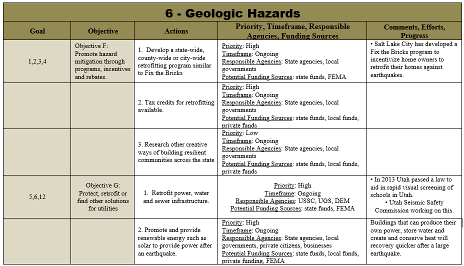
We also need to make mitigation part of the normal conversations we have about earthquakes in Utah. In 2019, our partners came together for the Utah Unreinforced Masonry Summit to discuss how our state can protect more people from earthquakes. Many of the discussions were based on research from an Envision Utah report called Your Utah Your Future, which found that disaster resilience isn’t on the minds of many Utahns, and it needs to be.
Joe Dougherty is the public information officer for the Utah Division of Emergency Management. jdougherty@utah.gov